The Riparian grazing management update session started at 11:00 AM. It was moderated by Dr. Howard Skinner. He introduced the speaker, Mr. Erik Hagan, a Pennsylvania State University graduate student working as the Riparian Conservation Planning Project Coordinator for Agriculture Research Service. Erik was the only presenter at this session. His presentation was about Shifting Perspectives in Riparian Conservation Planning: Trade-offs, Options and Opportunities in Managed Ecosystems.
Erik provided the membership his credentials. Currently he is a graduate student in the Ecology Program at Penn State University and Project Coordinator of Riparian Conservation Planning, USDA-ARS. Previously, he worked for the South Puget Sound Small Farms Program – Washington State University Extension and Mason/Thurston Conservation District.
He began his riparian conservation planning presentation with some guiding principles on trade-offs, options, and opportunities involved with conservation planning of riparian areas that are pastured. These principles are:
-
Objective justification for flexible riparian management (from farmers to policymakers)
-
Working with state and national programs to assess buffers and make recommendations.
-
Avoiding “bait and switch”, looking across the ecosystem services of the riparian area.
Driving Concern: Flexibility is critical: Policies and practices have trade-offs. Currently, regulations and policy are disengaged from reality. Maryland Department of Agriculture manure management regulations call for no livestock within 10 feet of a stream except at constructed stream crossings as no livestock excrement can be deposited in that setback zone. This means an exclusionary permanent fence very close to a stream, that if it floods out of bank beyond this fence, harms the fence and does not exclude the wash-off of manure contaminants lying beyond the setback area. The regulations were trying to minimize the loss of working farmland.
Conservation Reserve Enhancement Program (CREP) as part of the USDA Conservation Reserve Program has also given impetus to streamside permanent fencing with incentives to farmers to install filter strips and riparian forest buffers and to restore wetlands. This may be effective in many cases but removes the riparian area from the farm as usable working land. It also does not recognize that properly grazed pastures can be effective filters of sediment and nutrients in their own right.
He explained that the ARS - Penn State riparian management project is a 4-year project. Year 1 involved building a team, selling the concept of a riparian area planning tool, and reviewing the science. Year 2, that is nearly complete, was devoted to developing the tool and publishing it for peer review. Year 3, coming up, survey with the tool to test its assumptions and review its output for acceptability of its proposed guidance in managing riparian pastures for continued use as pasture in many cases while protecting riparian ecosystem services, such as water quality.
Objective justification for flexible riparian management is required. The Riparian Management Team reviewed 238 studies from around the Nation. They found that rules of thumb are not universal. Grassed riparian zones are better for:
-
erosion control (esp. small areas/small streams)
-
trapping sediment
-
infiltration/diffusion of runoff
-
drawing down nutrients
-
small headwater streams.
Forested riparian zones are better for:
-
Stream bank protection
-
denitrification (in-stream)
-
habitat (stream & buffer)
-
large streams.
These rules of thumb are undermined by:
-
Riparian soils/geology/hydrology,
-
Legacy sediments and nutrients, and
-
Upslope/up-watershed conditions (including management).
The choice of forested buffer versus a grass buffer creates trade-offs in riparian management that need to be considered as it relates to sediment control. A Maryland case study of erosion in a forested riparian buffer found that there was more concentrated flow in forest buffers creating gully erosion across them that dump sediment into the stream. Trees create shade so that understory growth and its root mass is sparse. With grassed buffers along streams, the idea is that it receives water that enters it as desired diffuse flows. The example he used shows that a sediment berm created by accumulated sediment at the cropland side of the grassed riparian buffer concentrates flows across the grassed filter.
(Editor’s note: However, more importantly the field side edge of these grassed riparian buffers are not on a level grade since they parallel a stream that is on a downhill grade no matter how small. In some cases, there may be a natural levee formed immediately adjacent to a frequently flooding stream that is higher than the rest of the floodplain. Therefore, the chances of diffused flows occurring across the entire length of the grassed riparian buffer is nil to begin with given those two situations. It does not enter as diffused flow but instead is diverted downstream in cropped fields by tillage or row crop furrows until a low spot or side channel is reached. A grassed riparian buffer between a pasture and a stream is unlikely to ever have a sediment berm built up at the streamside edge of the pasture. There will be virtually no sediment to trap unless there are scattered heavy use areas along it due to shady areas, feed bunks, water troughs, or livestock trails near the buffer.) In any event, management in both systems are needed to get a truly desired result rather than leave it to chance.
Trade-offs in riparian management need to be considered when dealing with reducing phosphorus and nitrogen runoff into streams with riparian buffers. Case studies present evidence that suggest buffers can become sources of phosphorus (P) pollution unless biomass is harvested:
-
Particulate P build up from sedimentation
-
Release of legacy and soluble P in leaf senescence from buffer to stream
-
Woody biomass can sequester more P in the long run than vegetative biomass
-
May present remediation strategy through harvesting biomass, such as hay or by flash grazing.
It may be better to trap P in upland buffers rather than at a riparian buffer so as not to have P be remobilized by floodwaters and swept away to enter bays, estuaries, lakes, and ponds downstream.
As for nitrogen, denitrification occurs best in static systems:
-
Saturated Soils
-
High organic matter soils
-
What is the management objective of the site?
Pastures in saturated soils generally have high organic matter due to a high degree of root turnover (annual root death and regeneration of new roots) so that denitrification can occur well there. If the objective is to pasture livestock in the riparian area, this may be an ideal way to leave the land rather than convert it to cropland if pasturing livestock ends up being an onerous situation due to misguided policies and regulations. In time, cropland will likely draw down soil organic matter, and there is no guarantee that a grassed buffer will be between stream and cropland unless by edict.
Since the critical driving concern is to have flexibility in conservation planning riparian areas, there is a need to look at the soil types on a farm and tie them to ideal seasonal use. When are these soils ideally suited for crop production? What is their field production potential?
Introducing flexibility in riparian management, requires a common understanding of production and environmental concerns and achieving a balance acceptable to the farmer and the lead agency involved in the management plan. It is, therefore, necessary to work with state and national programs to assess the true worth of various buffers and make recommendations using realistic effects assessment to achieve a proper balance between production goals and environmental goals.
Agricultural Research Service, Farm Service Agency, Natural Resources Conservation Service, US Forest Service, Penn State University, and Virginia Tech University are looking at 300 CREP contracts out of 25,000 in the Chesapeake Bay Watershed. They are looking to see how CREP planning can be improved in the Bay Watershed by using flexibility in riparian management. The Chesapeake Survey
will evaluate the distribution of riparian ecosystem services by doing:
- Ecological assessments - This does not account for production benefits.
- Production And Conservation Trade-offs (PACT) - ARS/Penn State assessment tool.
- Comprehensive but does not include impact/quality gradients (either/or)
- Watershed modeling - Predict water quality impacts of management practices.
Ecological assessment is done by using first, the Stream Wetland Riparian (SWR) Index. SWR Index was developed by Penn State Riparia in 2009. It evaluates the condition of a stream and its associated wetlands and riparian areas. SWR Index is field-based, with an accompanying Landscape Index.
The next tool in the ecological assessment is the Index of Biological Integrity (IBI) adopted by PA Department of Environmental Protection in 2012. It uses several component metrics to evaluate biological integrity of macroinvertebrates:
-
Taxa Richness
-
EPT Taxa Richness (abundance of macroinvertebrates of the orders Ephemeroptera, Plecoptera, and Trichoptera)
-
Shannon Diversity
-
Beck’s Index
-
Hilsenhoff Biotic Index
-
Percent Sensitive Individuals
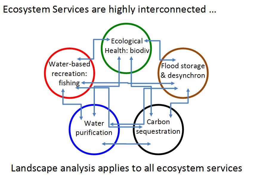
The second assessment tool used in the Chesapeake Survey is the Production And Conservation Trade-offs (PACT) assessment tool. This involves a very large Excel spreadsheet that evaluates both grazing systems and cropping systems in riparian areas. Management practices are performance rated based upon the applicable literature based on the ecological services that are provided and divided up into three classes: provisioning services, regulating services, and supporting services. Provisioning services are the products derived by cropping or grazing the site in question.
For pastures, this would be the forage produced on the site to feed the grazing livestock. On cropland, it would be the harvested crop grown there. For woodlands, it would be timber products. For pasture and woodland, it could be recreational opportunities. There are also some general provisioning services such as water supply, pollinator habitat, biofuels production, and incentive based conservation programs. Regulating services includes erosion and sediment control, water storage and desynchronization, water purification, nutrient cycling, and soil health and climate regulation. Supporting services would be wildlife habitat, ecosystem health and productivity, and biodiversity of water-loving animals and plants.
Eric then went through a number of different scenarios using PACT to rate different pasture and land use management situations. Example 1 was a continuously grazed, highly utilized pasture with a degraded streambank, and an unrestricted livestock access to the creek. A series of four slides depicted how the applied practices affected provisioning services and natural resource (regulating + supporting services). Example 1 got a total score of -2.53. Provisioning services got a total +1.44 score. While for natural resource services, example 1 got a total -3.97. One thing that was overlooked, however, was manure was applied, since it was a pasture. The grazing animals applied the manure. This would have made the score slightly lower. It is the very reason for excluding livestock from streams. However, their application is much more scattered than as applied by a manure spreader, a blanket application.
Example 2 was a well-managed, rotationally grazed pasture with a narrow riparian exclusion and grassed buffer. Its total score was +9.69 having both services, provisioning and natural resources, with positive scores.
Example 3 was a CREP Riparian Forest Buffer, a 15-year old CREP riparian forest buffer practice with complete removal of livestock from riparian corridor (100ft from top of bank). It had a negative provisioning score, but a positive natural resources score providing a total score of 5.48, intermediate between the two pasture scenarios. Since the forest buffer is only 15 years old, it will be a wait before it yields some timber products or possibly merchantable nuts depending on tree species planted.
The third assessment tool used in the Chesapeake Survey is watershed modeling using the Soil & Water Assessment tool (SWAT). This is used to answer these questions:
-
What do buffers give us?
-
Can we use different BMPs to the same effect?
Best management practices for nitrogen and phosphorus must be different since the two nutrients have very different cycling attributes. Nitrogen is ephemeral, easily lost from the soil, whereas phosphorus once applied to the soil tends to remain there for a long time either as a soluble nutrient or an insoluble mineral. Their pathways to live streams can also be different depending on the soils and management by the farmer.
In an example of a forested riparian buffer along a stream bisected by a field ditch, it was clear that the ditch carried most of the upstream watershed through the buffer untreated. Only a small area of cropland near the buffer drained directly towards the buffer where the buffer could capture sediment and particulate P, and assimilate dissolved P and N through uptake by the trees or denitrification of N by the underlying soil. In response to ill-planned buffer locations, a performance-based buffer locating tool, Ag Buffer Builder, has been developed. It shows where the sediment and nutrient loading is most probable along the buffer’s length. It can be applied to farm parcels.
The Agricultural Conservation Planning Framework is a tool that does watershed planning for BMP implementation by determining the riparian function along stream reaches. It determines five different riparian functions of stream reach segments:
-
Intensified nutrient uptake
-
Diversified vegetation
-
Sediment trapping
-
Deep rooted vegetation
-
Stream shading/bank stabilization
Further planning tool development is to combine ecological indicators, PACT assessments, and landscape context modeling into a planning tool that aids planners and land managers in discovering where to locate best management practices to reduce sediment, N, and P loss and enhance other ecosystem services. Eric showed the ecological pyramid recently proposed by CSA News. It shows the base of the pyramid being labeled “build soil health”, with the next layer above being “control water within fields”, then “control water below fields”, with the very top of the pyramid labeled “riparian management”.
Riparian management cannot be the only line of defense and, without the other practices being done first, is most likely doomed to failure. With pastures, uncontrolled grazing after a riparian buffer has been established by fencing off the near stream area will render the buffer useless in time if not immediately for nutrient loss mitigation. Streambank stabilization may be its only benefit.
Futuristic conservation planning may consist of alley cropping, short rotation coppicing of trees,
silvopasture, and multi-story cropping with working buffer zones and riparian buffer zones where needed. (Editor’s note: This will depend on how flexible American agriculture is today that continues to mechanize with ever larger farm equipment on larger and larger farms. Hand labor is shunned.)
Eric also introduced us to the Northeast Agroforestry Professional Development Training. They are developing agroforestry strategies and application manuals specific to the Northeast. Professional development on agroforestry practices application for technical service providers, farmers, and consultants is their goal.
The Take Home Points are:
-
Flexibility is key. Both sides, landuse agencies and the farm community, must recognize the opportunity to enhance in a sensible and sensitive manner.
-
It all depends on Site Context, Environmental Context, and Management Context.