After lunch break, the next session starting at 1:30 PM was Pastureland National Resource Inventory - Description of Data Collection & Its Goals moderated by Mr. Rob DeClue, Area Grazing Lands Management Specialist, Chenango Co. Soil & Water Conservation District, NY. Mr. Sid Brantly, the new Natural Resources Conservation Service National Range and Grazing Land Ecologist, was the first presenter. He presented the National Perspective of Pastureland NRI, Objectives & Anticipated Results. He described the National Resource Inventory (NRI) as a snapshot in time of our agricultural land resources and condition. It gives soil loss estimates, agricultural landuse conversions such as loss to development, and for rangeland and pastureland the NRI also measures their ecological status. Rangeland, grazed forestland, and pastureland national acreage has been on a slow decline from 1982 to 2007, declining from 614,838,000 acres to 583,858,000 acres.
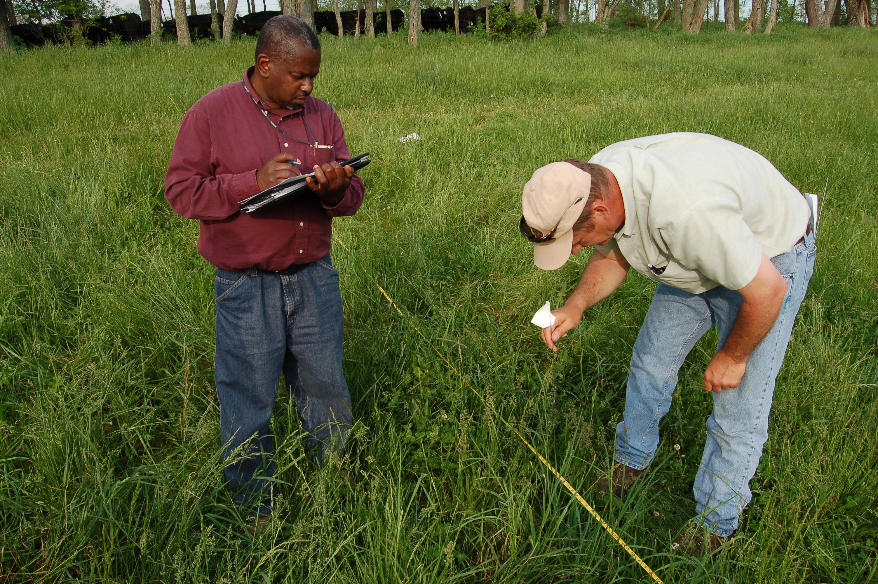
We have been doing a very much more intense data collection for pastureland NRI since 2009 by test-ing a new set of protocols to measure the plant community present in our permanent pastures. Plant species composition is determined in random plots selected on pastureland and several field measure-ments are done to determine biomass, canopy height, legume content, among other datum.
NRCS is getting ready for 2014 pastureland NRI. On February 6, 2014 start up teleconferences will be held for each of the 3 NRCS regions of the US, East, Central, and West. February 18-20, 2014, protocol webinars will be held for each of the 3 regions. National NRI Grazing Land Training sessions are planned on February 24-28, 2014, in Tucson, AZ; March 31-April 4, 2014, in Auburn, AL; and April 28-May 2, near Des Moines, IA. Several modifications to the pastureland data gathering protocols are planned that will make the pastureland inventory unique from rangeland. Both are grazing lands, but they have dissimilar plant communities and productivity that need to measured with a different, but complementary set of protocols.
Mr. Kevin Ogles, USDA-NRCS East National Technology Support Center Grazing Specialist, gave his presentation, NRI On Pasture - Regional Overview, remotely over the conference room phone line. His presentation was displayed while he narrated it. In an overview, he said NRI Grazing Land on-site data has been collected on rangeland since 2003. NRI pasture pilots on cooperator farms were conducted in 2009-2011. No data collection on pasture was done in 2012 due to the lack of funds. NRI grazing land on-site survey data using NRI sample segments is collected on pastureland starting in 2013.
The 2014 non-federal pasture sample will be a part of the 2014 photo-interpreted NRI. It will be conducted in 48 states using NRI sample segments. NRCS will collect data for the first two eligible points (non-federal pastureland) found in the randomly selected sample segments upon verifying in the field that the GPS located points are actually in pastureland. NRI grazing land data collection time-line will be based on the USDA Plant Hardiness Zones map. For pastureland in the East Region, data must be collected in the Southern Zones by July 15th and in the Northern Zones by September 1st. All data review needs to be completed within 2 weeks of data collection.
Time-lines will be tweaked in 2014 as needed to keep data collection time-line as tight as possible. For 2014, two measurements have been designated as optional (soil stability test) and not applicable (Species Composition by Weight [production]). With the latter, it can be handled by using Standing Biomass and the optional Dry Weight Rank (DWR) Method. The total aboveground biomass is simply multiplied by the percentage of the plant species found to be present by the DWR Method.
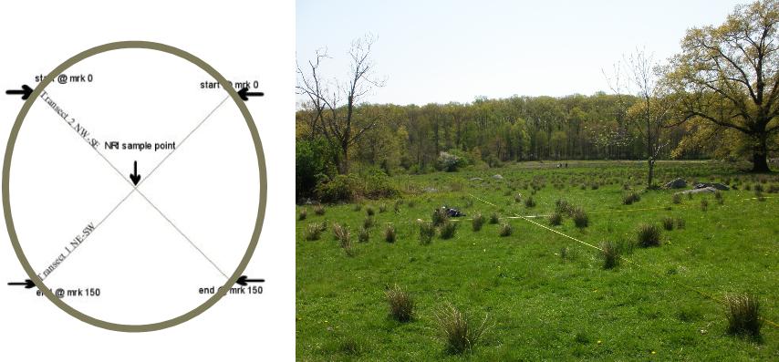
In pastures, soil stability is generally high, at or near optimum. Each sample point has two transects radiating through them at right angles to each other, one runs NW-SE while the other runs NE-SW. Much of the data collected is along these two transects. Plant species data is also collected in each of the 4 quadrants formed by the transects, such as the presence of woody species and infrequent herbaceous species present.
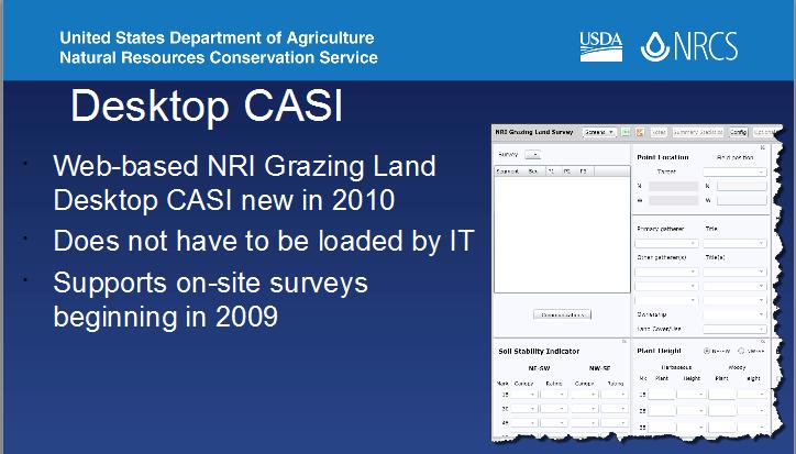
Data is recorded on a NRI Grazing Land Survey Instrument. It is a web-based computer assisted survey instrument, CASI for short, developed at Iowa State University. It can download and upload sample segments (PSUs). It is used to enter and edit data. Some recorders find it easier in some sit-uations to use clipboard, paper, and pen to make some entries before entering it into the CASI. The web-based NRI Grazing Land Desktop CASI became available in 2010. It supports on-site surveys beginning in 2009 so none of the older hand recorded data is lost.
NRI On-Site Survey Progress Reporting Status is on-line. This provides status of sample segment data collection by survey year and state. Technical leaders at state, regional, and national levels can see how data collection of points is progressing by state.
Training videos of grazing land transect protocols are on Transect Layout, Documenting the Plot with Photographs, Ecological Site Determination (range), Canopy Gap (range), Line Point Intercept, Soil Stability (range), and Production. These videos are produced by NMSU, ARS, and the Herrick Production Company. To ensure data collectors are proficient in NRI grazing land on-site study protocols before they begin collecting data, there is a formal authorization process for them. This formal author-ization process standardizes training of data collectors. They must pass calibration exercises. There is a written post-training test. It also requires a performance-based post-training test during the data collection process. There are two levels of authorization:
Technical leader
- Highest level of authorization
- Must be proficient in all grazing land on-site study protocols
- Each field crew must have at least one member authorized as a technical leader
Crew member
- Lower level of authorization
- May not be proficient in all grazing land on-site study protocols
All data collectors (NRCS or contract) are required to complete an annual training session to be authorized to collect NRI on-site data for the data collection year. Data collectors may attend the national training or a state or multi-state training. All data collectors (NRCS or contract) responsible for data are required to complete a confidentiality agreement. NRI data and points are protected from private and public viewing. To date pastureland NRI has noted differences from anecdotal observation and measured results in these relevant topics:
- % Legumes
- Idled grasslands
- Diversity of Pasture VS. Range
- Amount Pasture in Poor Condition
- Amount of Pasture Lost to ‘Other’
The amount of pasture lost to other can be subjective at times. Some fields that are visited and have not been grazed in the current season can appear to be no longer grazed (idled). It is best to err on the side that they may be grazed at some time later in the year. In other situations, it may be clearer that the land is reverting back to forest or is a rural home-site that has no livestock.
Percent legume by weight is often over-estimated by eye since they have more leaf area but have thinner stems. Plant diversity in permanent pastures tends to be as high or higher than rangeland. All pastures naturalize with time and in so doing become more plant species diverse. Grazing causes enough disturbance to allow other species to germinate and grow in any slight gap in the canopy.
Ms. Susan Parry, USDA-NRCS State Grassland Conservationist for Pennsylvania, was the last presenter for this session. Her presentation was Pasture NRI Field Experience in PA. She gave some background on the years when PA was one of the states to test the protocols for pasture NRI. PA began in 2007 with 4 other states, after several years of work with protocols nationwide for rangeland NRI. Fifteen PA farm locations representing a diversity of conditions, easy access and landowner permission were used that year to collect pasture NRI data. Maps identifying field boundaries, cultural features, and soil types were used. Digital latitude and longitude information was also recorded.
NRI staff at Iowa State University, Center for Survey Statistics and Methodology (CSSM) selected 10 out of the 15. PA NRCS staff performed the transect survey on two valid points within each segment location. PA continued to collect data in the following years except for 2012. Other states were added to the pilot test. In 2013 Statewide Pasture NRI pre-data collection required landowner access permissions, sample point locations, site maps, soils maps, confidentiality agreements, and training. PA pasture NRI training and calibration exercises were done to ensure all data collectors perform protocols consistently for precise data results. This was achieved by:
- Performing protocols on same sets of transects
- Comparing data obtained by multiple teams
- Field team leader is present to observe
- Conducted during training session, and again
- Two additional calibrations during field season (one if fewer than 15 segments validated)
East Region 2013 pastureland NRI training was done at Troy, NY. Supplies
and equipment needed are:
field PC (Trimble unit), digital camera, measuring tapes (2/150 ft.),
survey pins and flags, clipboard, compass, and clinometer. For the PA
2013 Pasture NRI, we were assigned 14 segments (42 points) in 12
counties. However, 30 points were eliminated due to change in land use
or ineligible for data collection, change in landowner and could not
reach new landowner, and denied access on two. Therefore, only 12 points
inventoried in 7 counties. Of the 12 points, 5 were grasslands. Others
were “capable of being grazed” with some improvement, including
infrastructure and plant condition. Teams consisted of a soil scientist,
team leader, a regional grazing specialist, and student intern.
Here are their assigned duties:
A= Soils staff person; B= Team Leader; C= Grazing specialist; D=
Student Assistant
- A does GPS with/or in CASI to locate point, B prepares dry erase board/signs for photos while assisting C (or D) who lays out tapes for transect.
- A verifies soil at point and takes all photos and board (D could help here), while B & C begin Line Point Intercept and Canopy Gap protocols.
- B does Disturbances, Resource Concerns, and Conservation Practices (D could help here) while A & C finish Line Point Intercept and Canopy Gap.
- A & C do DWR, then PCS, WHILE
- B does Standing Biomass clipping (D could help here).
- ALL do Plant Census.
- ALL three (or four) people gather to reach consensus on recorded PCS scores, disturbances, conservation practices, & resource concerns and get all protocols into the CASI (or finalize paper version).
PA 2013 Pasture NRI Schedule:
Southeast counties were done in mid-June;
Northeast (Bradford, Centre) early July;
* West (Allegheny, Crawford, Elk, Lawrence, & Washington) were done in
second week of July.
Nationally in-field reviews require each Field Team Leader to visit at least 5% of the segments completed. The PA Field Team Leader and student assistant were part of the team for every point done in PA. Laying out the transects can be challenging at times. They can be in tall grass or mowed grass, center point in a fence line, center point in a yard, or center point in a crop field, and even in line with an obstruction such as a utility pole. This led Susan to say “NRI is like a box of chocolates- You never know what you’re gonna get!”
Some of the additional features of the CASI are the recording of resource concerns present in the pasture, yes or no; the presence of conservation practices, yes or no; and pasture condition score sheet factors to rate besides the vegetative data gathering. Post-Collection data review can identify anomalies/data entry errors of data posted daily during field season. The Team Leader/State Grasslands Conservationist review and resolve. Password-protected review tables are posted. It is done on-line (CASI website) within two weeks. NRI Grazing Land Images Website stores digital field photos (lots of them!) to a temporary database. Tag photos with identification and mask out confidential information before submitting to a permanent database. View tagged images and review and edit as needed.
Lessons learned:
- Support/Technical staff contact info – have it with you!
- Paper copies on hand for every site (hand-held failures)
- Bring plastic bags for DW samples instead of paper in case of rain!
- Label all sheets and sample bags before going to the field
- Keep all scrap paper until you figure out if it is “scrap!”
- Don’t forget your user name and password for the CASI website.
Looking forward to 2014 NRI…